
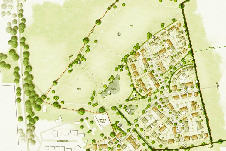
THE formal planning application for 156 dwellings to be built on land at Marsh Farm Ross-on-Wye has been submitted to Herefordshire Council.
The application requesting outline planning also includes the demolition of two properties in the the Glebe, and adaptation to a third property to facilitate vehicular access along with the demolition of a number of agricultural outbuildings.
However, the application states that the developer Landra Developments Ltd would make provision for a public open space, the landscaping of green corridors and provide sustainable urban drainage systems and engineering works including foul water pumping station and an electrical substation.
However, there has been a lot of opposition to the proposals when the scheme was presented to Ross Town Council where access to the new estate was a top priority.
Cllr Bev Pope suggested that an alternative route through Ross Enterprise Park should be considered.
Landra Developments also held a public consultation event at the Larruperz Centre where more than 100 residents attended the public consultation and heard that 40 per cent of the proposed housing would be much-needed affordable homes.
The application acknowledges that Welsh Water do not consider that the existing sewer which passes through site is suitable to receive additional flows.
The developer states that it is proposed that foul drainage would be discharged to the local Welsh Water sewer network via a pumping station.
This application proposes the development of up to 156 dwellings. It is anticipated that these will be a mixture of semi-detached, detached and small terraces.
The developer’s agent states that these dwellings will be between three and five bedroomed properties, catering for families but the precise mix of housing will be agreed at a later stage in the planning process.


However, the developer has proposed that a minimum of 40 per cent of the dwellings planned will be affordable in nature, subject to consideration of viability.
Prior to work ceasing on the Herefordshire Local Plan 2021-2041, the application site had been allocated as a strategic mixed-use site – which included the delivery of a minimum of 1,000 dwellings.
However, the application is accompanied by a building heights parameter plan which limits the heights of buildings to a maximum of two -and-a-half storeys, with two-storey buildings being proposed around the edges of the site.
The design of the proposed housing will respond to natural features and the topography of the Site and its setting within the wider landscape.
The developer states that the proposed access to the site will be via The Glebe but this will require demolition of two houses and the reconfiguration of a third property’s garage and the removal of its drive.
The agent, Lichfields, also states that no residential development is proposed within Flood Zones two and three located in the north and north west of the site.
It is proposed to discharge surface water run-off from the development to the local water course network via sustainable drainage systems features that include creating two attenuation ponds, engineered basins designed to temporarily store stormwater runoff during heavy rain and release it slowly into local drainage networks.
The agent also points out that as Herefordshire Council cannot demonstrate a five-year housing supply and cannot meet its target as a reason for granting the planning permission.
Lichfields considers that the adverse impacts of granting permission would not significantly and demonstrably outweigh the benefits and said: “As a result, we consider that the principle of development is acceptable in line with council policies and the proposals are in conformity with the development plan when read as a whole.”
Isca Archaeology advise that the site has low potential for significant remains relating to the Romano-British period.
The organisation states there is higher potential for remains relating to more recent historical periods, in particular there is a potential for remains relating to post-medieval agricultural activity such as field boundaries, modern agricultural outbuildings and the below-ground remains of the former Hereford, Ross and Gloucester railway. Such remains, would be of a markedly lower level of significance than those of earlier periods.
The application states that along the periphery of the site, ‘low light’ areas have been established to reduce the potential impact of the proposed development on surrounding ecology by creating a gradual reduction in illuminance levels from the roadways within the core of the development to areas of dark habitat.
Find out about planning applications that affect you by visiting the Public Notice Portal.
Comments on the application, number P262193/O, can be made via Herefordshire Council’s planning portal by Friday, September 11.
Comments
We've recently changed our login process. If you have an account for commenting, you will need to re-register on the login window.
This article has no comments yet. Be the first to leave a comment.